

Farming in Alberta has been shaped by a deep and layered history of geological, biological, and human forces. This article takes us back to the beginning.
Farming is based on a sliver of soil that caps kilometers of sediment and bedrock. To understand how our fields first formed, we need to read an ancient geological story of how Alberta has been raised and tilted then scoured and capped over time. Alberta has sat inside a continental plate (or ‘craton’) for over 300 million years. Around 180 million years ago, the western edge of this plate began crunching to form the up-and-down terrain of the Coast Mountains of British Columbia (B.C.) and the Rocky Mountains between B.C. and Alberta (Figure 1). Mountain building finished about 50 million years ago.

For almost 200 million years, Alberta has been tilted: our bedrock is formed largely of shales and sandstones that built up when sediment either poured off the mountains and solidified into rock or settled down in ancient waters that once filled a basin over Alberta. From about 50 to 5 million years ago, huge sheets of gravel and sand continued to shed off the Rockies (carried by rivers and streams) before settling into our basement.
After 2 million years ago, Alberta experienced cycles of cold and warmth; enormous ice sheets slowly enveloped the province from two sides. Mountainous B.C. sent a ‘Cordilleran ice sheet’ east that slowly iced over our foothills while a ‘Laurentide ice sheet’ spread from northeast Canada and sluggishly head-butted the Cordilleran ice right over Alberta. Ice sheets were up to 2 km thick. These massive bulldozers scraped and dumped rock and sediment like a conveyor belt (Fensome et al. 2014:220). This smoothed out Alberta’s prairies, created small depressions that form our modern wetlands and re-set the soil formation clock to zero. Louis Agassiz, an early geologist in North America, wrote in 1864: “The glacier was God’s great plough; and when the ice vanished from the face of the land, it left it prepared for the hand of the husbandman [farmer].”
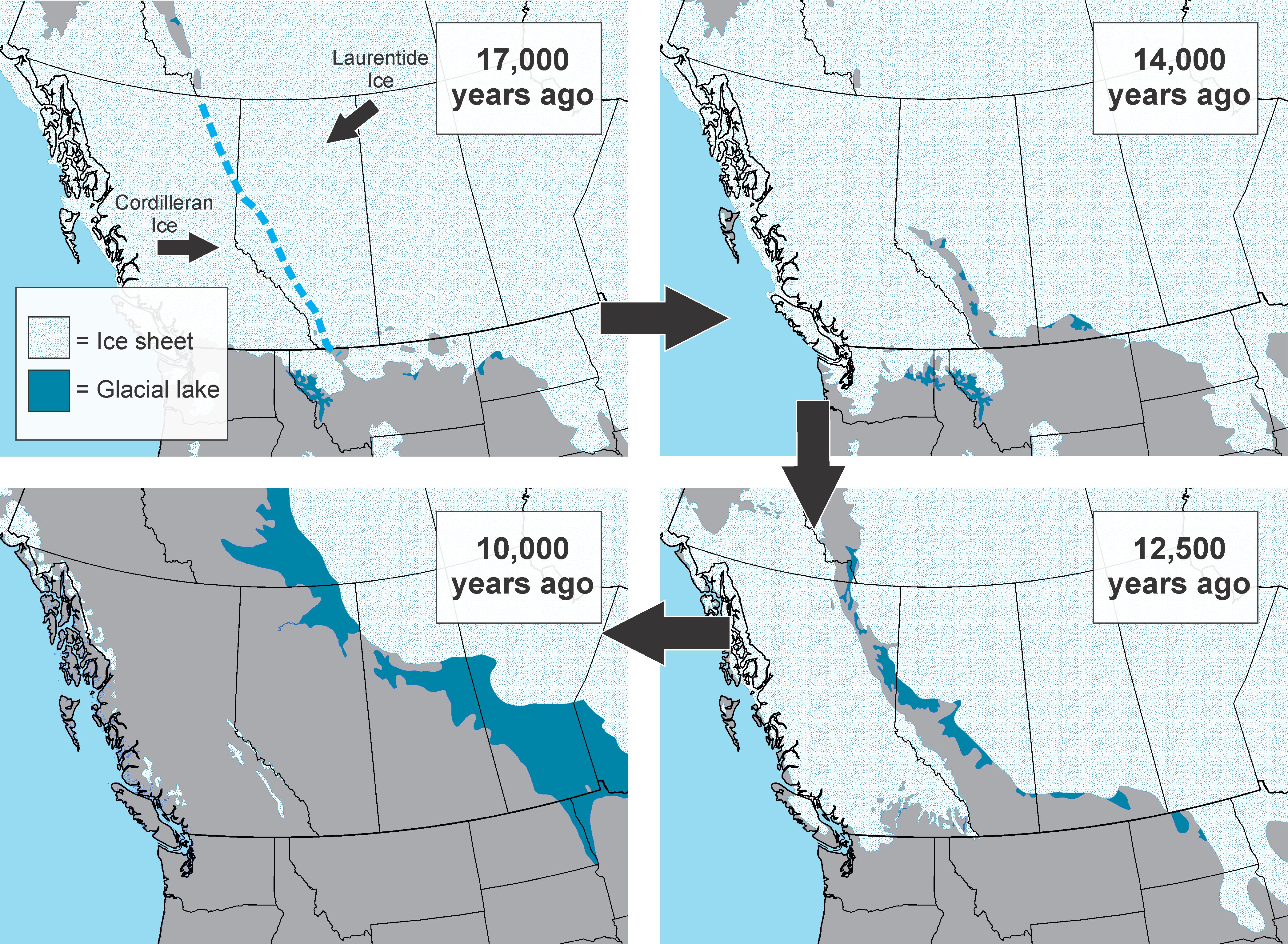
When the ice melted, it retreated both west and east with Alberta locked in the middle in an ‘ice-free corridor’. How did this shape agriculture? For several thousand years after the Ice Age had ended, ice melt flowed down from the west and delivered sediment to large glacial lakes that were dammed by ice over parts of Alberta. Imagine water flowing down a ditch to a blocked culvert. Large parts of the province were covered in pools of trapped water where finer materials, like clays and silts, dropped out. These fine-grained sediments on top of sheets of gravel and sand are now important for retaining moisture: most of Alberta has a relatively stable and shallow source of high quality groundwater.

After the great Ice Age (from 10,000 years on), Alberta soils began forming through biological action. Most of the province was initially covered by grasses, which made fertile soils because, over thousands of years, natural grasslands store organic content within the soil (through their roots), as opposed to forests that build up most of their organic content as leaf litter and humus above the soil (Fuller 2010). Much of northern and western Alberta was eventually covered in forests so why did the prairies stay prairies? Firstly, trees require more moisture. Moist and warm air rises from the Pacific Ocean and blows east towards Alberta but B.C.’s mountains deflect much of that air up where it cools and drops its water. A relatively small percentage of airborne water hits Alberta. From that point, hotter temperatures in the southern part of the province (and strong winds) cause a high rate of water loss to the air (evaporation): most of southern Canada’s prairies are water-stressed in terms of rain. Here is where grasses thrive.

Secondly, four-legged and two-legged engineers fought off the forests. Biologists call much of Alberta a ‘buffalo landscape’ because millions of these animals (properly called bison) pounded the prairies, grazed along its margins, and stamped out the spread of trees and shrubs. For thousands of years people have also been burning grasslands and parklands in part to provide food for bison (lush grass grows in recent burns). Bison, people, and a combination of soil characteristics are thought to explain why grasslands extend through central Alberta and up to the Peace Region north of the appropriately named Grande Prairie and High Prairie.
Because Alberta soils started forming around 10,000 years ago, they have not been leached (when water carries away minerals and nutrients) like other parts of the world. Our northern geography helps: water does not constantly pour through Alberta soils for the simple fact that it’s frozen much of the year. A sharp spike in spring melt, however, filters through our young soils and replenishes groundwater.
Over 200 million years of mountain uplift, sediment pouring, and mountain-driven climates followed by 10,000 years of grazing and burning produced the inviting grasslands that greeted Alberta’s early farmers. Blackfoot First Nations in Alberta farmed tobacco in small plots for at least several hundred years before the spread of grains (e.g., wheat, barley, oats) and cattle ranching in the 1800s. The figure below is a timeline of several events in Alberta that shaped the early spread of farming.

Over-hunting in the first half of the 1800s wiped out bison herds and opened the prairies to cattle while treaties in the second half of the 1800s saw many First Nations settle on reserves. The Dominion Lands Act was passed in 1872, which encouraged homesteading in Western Canada and railways completed to Calgary (1882) and Edmonton (1891) made it possible to move immigrants, livestock, machinery, and supplies. All of this contributed to settlement and an agriculture boom.
While wheat was sown around Fort Edmonton in the 1820s, it didn’t spread in Alberta until hardy varieties like Red Fife arrived 50 years later. The more widespread availability of horses (for ploughs), machinery (e.g., seed drills for more successfully planting crops), and irrigation all opened new plots for cultivation. By 1915, southern Alberta was considered one of the greatest wheat-growing areas in the world.
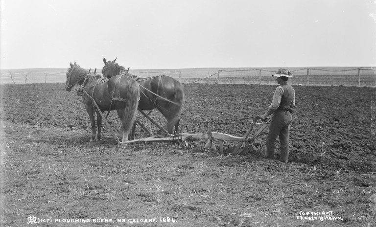
The rapid rise of farming had a big impact on Alberta soils. Deep tillage was common: ground was ploughed 15-30 cm deep (6-12 inches) or more to improve water absorption, break up surface roots, recycle nutrients, and create holes for seeds. Summer fallowing was also practiced: large croplands were purposely left out of production every few years to save moisture and nutrients. High winds and spring rains, combined with periods of drought, did a number on the broken up soil. Tens of centimeters of topsoil blew away and crippled productivity, not to mention ‘tillage erosion’ when dirt moved from hills and ridges on farms downslope to basins and wetlands. By 1926, 10,000 farms in Alberta were abandoned due to crop failure. In response, farmers adopted practices to preserve soils, along with a list of other measures, to maintain fertility and maximize yield.

Heritage Art Series
The deep history of farming goes back over 200 million years to geological forces that shaped our landscape. We are still shaping rural landscapes through new farming practices, water diversion, recreation, and other industrial development. Taken together, Alberta soils preserve a complex layered history of landscape change. ‘Canola Fields’ pictured below by Edmonton-based fibre artist Leah Gravells perfectly captures this history. And the art medium (quilting) is appropriate because farming and quilting go hand-in-hand in Alberta’s history. The Heritage Art Series is a shared project of the Historic Resources Management Branch, the University of Alberta, and the Royal Alberta Museum: each artwork tells an important story about the people of our province. We hope it fosters a greater awareness of our past and instils a deeper respect for it.
More stories and colourful scenes from Alberta’s past, from guns and ammonites to boats and woolly mammoths, can be viewed here.

Written By: Todd Kristensen (Archaeological Survey of Alberta).
Thank you to David Spiess (Alberta Agriculture and Forestry) for assistance.
Further reading:
Agassiz, Louis. 1864. Ice –period in America. The Atlantic Monthly 14:93.
Anderson, C.H. 1975. A History of Soil Erosion by Wind in the Palliser Triangle of Western Canada. Historical Series No. 8. Research Branch, Canada Department of Agriculture, Ottawa, Ontario.
Anderson, Darwin, and Darrel Cerkowniak. 2010. Soil Formation in the Canadian Prairie Region. Prairie Soils and Crops 3:57-64.
Dyke, A.S., J.T. Andrews, P.U. Clark, J.H. England, G.H. Miller, J. Shaw, and J.J. Veillette. 2002. The Laurentide and Innuitian ice sheets during the Last Glacial Maximum. Quaternary Science Reviews 21:9-31.
Eyles, Nick, and Andrew Miall. 2007. Canada Rocks: The Geological Journey. Fitzhenry and Whiteside Limited, Markham, Ontario.
Fensome, Robert, Graham Williams, Aïcha Achab, John Clague, David Corrigan, Jim Monger, and Godfrey Nowlan (editors). 2014. Four Billion Years and Counting: Canada’s Geological Heritage. Canadian Federation of Earth Sciences and Nimbus Publishing, Halifax, Nova Scotia.
Fuller, Les. 2010. Chernozemic Soils of the Prairie Region of Western Canada. Prairie Soils and Crops 3:37-45.
Swindlehurst, Edward B. 1967. Alberta Agriculture: A Short History. Department of Agriculture, Government of Alberta, Edmonton, Alberta.

3 thoughts on “Plough your Furrows Deep: The Foundations of Agriculture in Alberta”